Some facts about Port-Louis
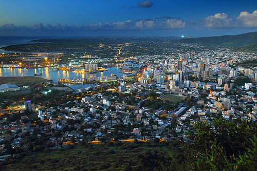
Port Louis (French: Port-Louis) is the capital city of Mauritius, located in the Port Louis District, the western part also lies in the Black River District. Port Louis is the country's economic, cultural, political centre and most populous city. It is administered by the Municipal City Council of Port Louis. According to the 2012 census conducted by Statistics Mauritius, the population was 148,001.
History
Port Louis was already in use as a harbor in 1638. In 1735, under French government, it became the administrative center of Mauritius and a major reprovisioning halt for French ships during their passage between Asia and Europe, around the Cape of Good Hope. The Port is named in honor of King Louis XV. During this period of French colonization, Mauritius was known as Ile de France. The French governor at that time, Bertrand-François Mahé de Labourdonnais, contributed to the development of the city. Since Port Louis was relatively well-protected from strong winds during cyclones by the Moka Mountain Range, Port Louis was selected to house both the main harbor and fort for the island. Value of the port continued during the British occupation of the island during the Napoleonic Wars (1800-15), and helped Britain control the Indian Ocean. However, port calls of ships fell drastically following the opening of the Suez Canal in 1869. Activity in the port increased during the seven-year closure of the Suez Canal (starting in 1967). Modernization of the port in the late 1970s has helped it maintain its role as the central point for all imports and exports from Mauritius. While Port Louis continues to be the business and administrative capital of Mauritius, expansion of the tourism industry in the late 1990s led to considerable development in Port Louis, with many shops, hotels, and restaurants being built in the Caudan Waterfront area.
Climate
Port Louis features a hot semi-arid climate (BSh) under KÖppen's climate classification. Its wettest months are from December through April where on average 60 mm (2.4 in) (or more) of rain falls during each of these months. The remaining months forms Port Louis's dry season. The city also shows a noticeable range of average temperatures. Port Louis' coolest temperatures are seen mid-year where average high temperatures are around 24 °C (75 °F). During the height of the wet season, the city sees its highest temperatures where average high temperatures are usually around 30 °C (86 °F)
Economy
The economy of the city is mostly dominated by its financial centre, port facilities, tourism and the manufacturing sector which include textiles, chemicals, plastics and pharmaceuticals. Port Louis is home to the biggest port facility in the Indian Ocean region and one of Africa's major financial centers.
Port
Port Louis is home to the nation's main harbor, and is the only official port of entry and exit for sea vessels in Mauritius. Ships must cleared in the port before visiting any other anchorage in the island nation.
The Mauritius Ports Authority (MPA), established by law in 1998, is the port authority responsible for Port Louis. The MPA provides port infrastructure, enters into contracts with private providers for port and cargo-handling services, promotes the use and development of the ports, and licenses and regulates port and marine services. The harbor adjoins the main city, with the port currently comprising three terminals.
Terminal 1 contains a total of 1180 meters of quay, with six berthing positions for cargo, passengers, and fishing boats.
Terminal 2 contains 986 meters of quays with six berthing positions, and includes specialized facilities for handling and storing sugar, fish, tallow, and caustic soda. In particular, the Bulk Sugar Terminal (operated by the Mauritius Sugar Terminal Corporation) can handle vessels with up to 11 meters of draft, can load sugar at a rate of 1450 tones per hours, and can store 175,000 tons of cargo. Also present in Terminal II is a dedicated 124-meter cruise ship jetty, with a dredged depth of 10.8 metres.
Terminal III has two 280-meter quays with a depth of 14 meters, and is specialized for handling container ships, having five post-Panamax gantry cranes. Also present are storage facilities for bulk ethanol and tie-in points for reefer containers. Vessels too large to dock at the quays can anchor at the Outer Anchorage, which is still within the official boundaries of the port.
Traffic Statistics - The number of ships visiting the port numbered at over 2,200 annually in 2010. Cargo traffic was slightly over 6 million tons, including containers representing 330,000 TEUs (twenty-foot equivalent units), 1.5 tons of bulk liquids (mostly petroleum), and 2 million tons of dry bulk items. Overall, the port contributes 2% to the country's GDP.
Cruise ship Terminal - opened in 2010 and named after Christian Decotter (past chairman of the Mauritius Tourism Advisory Board), illustrates the increasing role of tourism in the economy of Mauritius. Cruise ships of up to 300 metres can be accommodated at the facility, which includes two access bridges for passengers and vehicles. The facility was the first in the Indian Ocean to be capable of handling the largest cruise ships in the world. In 2012, passenger arrivals by sea included 11,510 tourists and 6,450 excursionists who arrived aboard 23 cruise ships.
Berthing facilities - are available at the Caudan Waterfront. Available are 20 berths with electrical and water connections, showers and toilets, laundry, and vehicle parking. Also available are dry dock and hull and sail repair facilities. Depths of the berths range from 2 to 4 meters, depending on the tide, and up to 30-meter ships can be accommodated. Also based in the port is the National Coast Guard facility, at Quay A of Terminal I